මෙ දවස් වල ගිනිකදු ගැන කතාවෙන නිසා මම ගිනිකදු වල පින්තුර ටිකක් දැම්මා.. ඔයාලත් බලලා හොදනම් Comment 1ක් දාල යන්න..
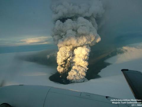
The Iceland Volcano eruption was immense, intense, and awesome. It stranded thousands of passengers in Europe and canceled vacations for many going towards Europe. The backlog of passengers is in the thousands due to the eruption of Eyjafjallajökull and cost the airlines billions. Mother nature doesn’t mess around. At the same time, eruptions are cool as hell. Check out 7 awesome volcano eruptions.


Sarychev Volcano Eruption - Spectacular Photograph
Photo and Description by NASA's Earth Observatory, June 2009
A fortuitous orbit of the International Space Station allowed the astronauts this striking view of Sarychev Volcano (Kuril Islands, northeast of Japan) in an early stage of eruption on June 12, 2009. Sarychev Peak is one of the most active volcanoes in the Kuril Island chain, and it is located on the northwestern end of Matua Island. Prior to June 12, the last explosive eruption occurred in 1989, with eruptions in 1986, 1976, 1954, and 1946 also producing lava flows. Ash from the multi-day eruption has been detected 2,407 kilometers east-southeast and 926 kilometers west-northwest of the volcano, and commercial airline flights are being diverted away from the region to minimize the danger of engine failures from ash intake.


Kuril Islands, northeast of Japan. This detailed astronaut photograph above is exciting to volcanologists because it captures several phenomena that occur during the earliest stages of an explosive volcanic eruption. The main column is one of a series of plumes that rose above Matua Island on June 12. The plume appears to be a combination of brown ash and white steam. The vigorously rising plume gives the steam a bubble-like appearance. The eruption cleared a circle in the cloud deck. The clearing may result from the shockwave from the eruption or from sinking air around the eruption plume: as the plume rises, air flows down around the sides like water flowing off the back of a surfacing dolphin. As air sinks, it tends to warm and expand; clouds in the air evaporate.
In contrast, the smooth white cloud on top may be water condensation that resulted from rapid rising and cooling of the air mass above the ash column. This cloud, which meteorologists call a pileus cloud, is probably a transient feature: the eruption plume is starting to punch through. The structure also indicates that little to no shearing wind was present at the time to disrupt the plume. (Satellite images acquired 2-3 days after the start of activity illustrate the effect of shearing winds on the spread of the ash plumes across the Pacific Ocean.)
By contrast, a cloud of denser, gray ash—probably a pyroclastic flow—appears to be hugging the ground, descending from the volcano summit. The rising eruption plume casts a shadow to the northwest of the island (image top). Brown ash at a lower altitude of the atmosphere spreads out above the ground at image lower left. Low-level stratus clouds approach Matua Island from the east, wrapping around the lower slopes of the volcano. Only about 1.5 kilometers of the coastline of Matua Island (image lower center) are visible beneath the clouds and ash.


 IF YOU LIKE MY POST PLS ADD REP ++

")


")


