Gustav's top winds got up to 115 mph (185 kph) Saturday morning, raising the storm to Category 3 status, according to the National Hurricane Center.
Hurricane Gustav is expected to pass over the western tip of Cuba later Saturday as it moves into the northwestern Caribbean.
Forecasters warn Gustav could grow to be a Category 4 hurricane as it barrels toward the U.S. Gulf Coast for a landfall late Monday or Tuesday. Gustav is the second major hurricane of the 2008 Atlantic hurricane season. Hurricanes are ranked 1-5 in intensity on the Saffir-Simpson scale. A Category 3 hurricane has sustained winds from 111 to 130 mph and is capable of causing extensive damage. A Category 4 has winds of 131 to 155 mph and can cause extreme damage.
As of 5 a.m. ET, Gustav was about 255 miles (410 kilometers) east-southeast of the western tip of Cuba. Fear and uncertainty about Gustav's position and strength by Monday sent emergency officials and politicians in the United States scrambling to prepare for a possible landfall somewhere along the Gulf Coast.
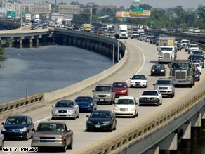
As Hurricane Gustav intensified on its projected path to the Gulf Coast -- ravaged in 2005 by Hurricanes Katrina and Rita -- residents packed and fled inland.
In Plaquemines Parish, where Katrina roared ashore as a Category 3 storm days after its initial landfall in Florida, Parish President Billy Nungesser called for a mandatory evacuation beginning Saturday at noon (1 p.m. ET). "As soon as it's safe to come back in, we will reopen the parish," he told CNN on Saturday. "We hope they take that warning."
Louisiana Gov. Bobby Jinal said more than a dozen parishes have declared states of emergency, adding that several coastal parishes began voluntary evacuations Friday and would begin mandatory evacuations on Saturday around noon (1 p.m. ET).
Gustav neared Cuba's western tip Saturday, packing winds close to 120 mph. The storm could reach the U.S. Gulf coast late Monday or Tuesday, as a Category 3 or strengthen to a Category 4, the National Hurricane Center said. Hurricanes are ranked 1-5 in intensity on the Saffir-Simpson scale. A Category 3 hurricane has sustained winds from 111 to 130 mph and is capable of causing extensive damage. A Category 4 has winds of 131 to 155 mph and can cause extreme damage.
Gustav's passage over Cuba took a toll on its wind speed, but it was heading over warmer Gulf waters, which are expected to reinvigorate the storm, according to the National Hurricane Center in Miami, Florida. The storm's passage over Cuba shaved just 15 mph off the top wind speeds reported by the hurricane center before it made landfall on the island. Forecasters believe Gustav will quickly regain that power and more, likely growing to Category 4 status on Sunday.
Hurricane warnings were posted for the northern Gulf Coast from Cameron, Louisiana, eastward to the Alabama-Florida border, including the city of New Orleans, Louisiana and Lake Pontchartrain.
"It is important not to focus on the exact track of Gustav as this is a large hurricane and significant impacts are likely to occur well away from the center," according tothe hurricane center's 5 a.m. ET discussion. A landfall around southern Louisiana is expected by Monday afternoon, theNational Hurricane Center said.