Latest ads
-
ZTE MF283U 4G Unlocked Router (Used)
- ayanthamaxi
- Updated:
-
 ලංකාවේ හොඳම උපකාරක පන්ති සහ ගුරුවරුන් එකම තැනකින් - TopTuition.lk
- dulithapathum
- Updated:
-
 Colombo RidhMathraa ’26 🎶✨
- Tmadhusanka
- Updated:
-
Colombo PXN V10 Pro Direct Drive Racing Wheel (Under Warranty)
- Abdur Rahman
- Updated:
-
USDT ණය සේවාව - USDT Loan Service
- පුරවැසියා
- Updated:
Microsoft Flight Simulator Addon Thread
- Thread starter fsgamer
- Start date
You are using an out of date browser. It may not display this or other websites correctly.
You should upgrade or use an alternative browser.
You should upgrade or use an alternative browser.
HAHAHAHAHHAHAHADon't pay attention to that motherfucker faggot CHINA. He is already to sucking nigga cocks in HELL along with his dad...
He was begging to suck my dick just before I splashed his wiggy brains out in Brussels last year, but too bad CHINA. You got to burn in hell forever and ever. Enjoy giving blowjobs and drink those cum down your ugly throat. ROT ROT in hell with all the puss and shit around you HA HA HA HA HA..

Guys(all members) listen up!
if anyone one of you have facebook or myspace.
PLZ try to share you addons links there!
Im just trying to help
if anyone one of you have facebook or myspace.
PLZ try to share you addons links there!
Im just trying to help
NO that will not working hahahaGuys(all members) listen up!
if anyone one of you have facebook or myspace.
PLZ try to share you addons links there!
Im just trying to help
eiekel dat werkt natuuurlijk niet dat weet je zelf ook wel of ben je zo zwatrt dat je niieks kan zien
OUT !!! HAHAHAHhehehehheheheIVE BEEN OUT FOR 5 DAYS AND IM STILL LOOKING AT THE PERSON WHO PRETENDING TO BE SURESKOCHI!
NO that will not working hahaha
eiekel dat werkt natuuurlijk niet dat weet je zelf ook wel of ben je zo zwatrt dat je niieks kan zien
im black?? have a good look to see if im really black!
Attachments

je bent zwaaart mie boy \im black?? have a good look to see if im really black!
lekker door blijven gaaan eiikel
FTX NA Blue Pacific Northwest
Info (click for more great screenshots)
(~3,95GB)


DOWNLOAD
DEAD LOL
PASSWORD
newcountry
Last edited:


I can not believe china bitch hasn't commented yet, LOL has he finally got the point?
More on less ROFL


FLIGHT PLANNING SOFTWARE
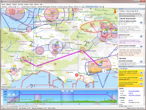
SKYDEMON http://www.skydemon.aero/
Start with our proprietary vector charts. Plan a route by clicking on consecutive waypoints. Alter your route graphically with the mouse by dragging it. Analyse the vertical profile of your route including terrain, airspace and landmarks. Watch as all TAF, METAR and NOTAM information for your flight is automatically downloaded and displayed. Use the fuel planning and weight and balance features to make sure all parameters of the flight are acceptable.
Export your plan to most Garmin/Magellan handheld GPS systems, or sync your route library and NOTAM data to SkyDemon InFlight at the touch of a button. Print a detailed paper plan with all flight parameters calculated and all relevant frequencies listed. After your flight, import your flight log from any of these devices back into SkyDemon Plan to plot it on the map, including a detailed vertical profile showing all features passed, airspace penetrated and terrain overflown. Analyse the aircraft parameters at any point in the flight.

SkyDemon is the excellent program for VFR flight planning. With current navigation and weather information that is loaded from the Internet.
30 days fully functional demo. Works fine with the program data fuck.exe (this program removes the restrictions on time of use)
DataFuck:
The program for "deception" of other programs that work only at certain times (time limeted demo software) and do not want to work more.DataFuck - a useful tool, which at the time you start trial program converts the system date back, after which the program can work in peace. It is really helps.
http://s46.radikal.ru/i112/0906/ed/9c4ffce04b04.jpg
DataFuck.exe is a Russian beauty and has Russian interface.
See the picture above and follow the instrution.
1. Place DataFuck.exe in the main folder of the programm u wonna fuck.
2. Click DataFuck.exe (Run it. Programma will ask u "файл конфигурации не найден, создать новый?" ("configuration file is not found, create a new one?"). We say "Да" ("Yes").
3. In the Box "Ффйл для запуска" enter what file u wonna run (you can use the "Обзор" ("Browse"). button). It must be the main exe file of programm.
4. In the Box "Дата в которой запускать" enter the date in which to run the program. Сourse entered date must be less than the final date of the demo period.
5. In the Box "Востановить как было через" put 2 or 5 seconds over this time cheated program should check the date and calm down.
IMPORTANT RUN THE FUCKED PROGRAMM BY PRESSING DATAFUCK.EXE
Last edited:
AVIATE4PRO FOR WINDOWS. DATAFUCK IT!!!
http://www.2av8.com/
This is the latest available installable version called AVIATE 4 PRO. It is a dynamic tool that is updated whenever needed or when new features are added. The database is available every 28 days according to the ARINC schedule and the Navdata is based on EAG (European Aeronautical Group) FMS data.
After the application datafuck.exe AVIATE4PRO will update it self to the latest version and you will get a new demo period.
Last edited:
IFR FlightPlanPRO http://www.flightplanpro.eu/Home.html
INFO:
Fast, painless, automatic – words not normally associated with planning a long distance IFR flight in Europe. FlightPlanPro, a full featured IFR route planning tool, moving from thinking about a destination to a fully planned flight is now just a few minutes work.
FlightPlanPro covers the area from Greenland to Luxor and supports planning in FIRs and UIRs. The information includes:
•Airway Structure including MEA, MAA and conditional route designation
•Waypoints/navaids that support the enroute airway structure (including
frequencies)
•All aerodromes known to CFMU
•Location data on 10,000 towns within Europe
•The Route Availability Document, accessible as a reference
•The UK Standard Route Document
•An elevation model showing terrain elevation in 3 mile grids
With a few pieces of information, IFR FlightPlanPro generates an airways flight plan (using Directs and altitude changes where necessary) respecting the RAD restrictions. If you are connected to the internet, this route is validated in real time by CFMU and automatically re-planned. Using this facility, most airways flight plans can be generated and validated in less than 60 seconds!
Even better, FlightPlanPro is a complete flight planning solution generating -
•A Plog for the route and your alternate - This is calculated using the GFS model and your aircraft performance to provide detailed winds aloft for each leg of the flight.
•A standard ICAO flight plan which can be printed, faxed or pasted into EuroFPL, Homebriefing or AFPEx on line filing services.
•A set of Trip Strips that show your route along with key IFR details, including intersections, MEAs, and VOR/NDB frequencies
•An ‘Operational Report’ provides a compact 2 column A4 report with METARS and TAFs for departure, destination and alternate along with a full narrow route NOTAM brief (NOTE - This is NOT an authorised source of official Notams) and JAR-OPS fuel reserve and W&B calculations
FlightPlanPro also, provides weather graphics including, freezing levels, cloud tops, cloud density, winds, and precipitation. These are overlaid on your route and the underlying airways and terrain information.
Similar threads
- Replies
- 6
- Views
- 1K
- Replies
- 10
- Views
- 507
- Replies
- 12
- Views
- 711