Latest ads
-
 Colombo Red Hat Certified System Administrator (RHCSA) - RHEL 10
- Sanjeewani95
- Updated:
-
 NURSING , CAREGIVER , HOTEL & BEAUTY COURSES
- IVA Para Medical Campus
- Updated:
-
 Handmade Character Soft Toys Peppa Pig Family
- anil1961
- Updated:
-
Video Content Creator
- pramukag
- Updated:
-
QA Engineer Intern
- pramukag
- Updated:
You are using an out of date browser. It may not display this or other websites correctly.
You should upgrade or use an alternative browser.
You should upgrade or use an alternative browser.

සැහෙන මහන්සි වෙලා තියෙන වගේ ... ස්තුති බෙදා ගත්තට ..
Ya
 Thanks machan!!

A tsunami tidal wave washes away houses in Kesennuma, Miyagi Prefecture, Friday, March 11, 2011 after strong earthquakes hit the area. AP / Keichi Nakane

A tsumani triggered by a powerful earthquake makes its way to sweep part of Sendai airport in northern Japan on Friday March 11, 2011. AP / Kyodo News

Sendai Airport is surrounded by waters in Miyagi prefecture (state), Japan, after a ferocious tsunami spawned by one of the largest earthquakes ever recorded slammed Japan's eastern coast Friday, March 11, 2011. AP / Kyodo News

The tarmac and surrounding area of Sendai Airport is covered with water after a tsunami at in Sendai, Miyagi Prefecture Japan on Friday, March 11, 2011. AP / Kyodo News

Vehicles remain overturned at Oarai town, Ibaraki prefecture (state), Japan, after a ferocious tsunami spawned by one of the largest earthquakes ever recorded, slammed Japan's eastern coasts Friday, March 11, 2011. AP / Kyodo News

People gather outside Sendai station after a powerful earthquake hit northern Japan on Friday March 11, 2011. AP / Kyodo News

Workers inspect a caved-in section of a prefectural road in Satte, Saitama Prefecture, after one of the largest earthquakes ever recorded in Japan slammed its eastern coast Friday, March 11, 2011. AP / Kyodo News

Train passengers wait at Tokyo's Shinagawa station to get first-hand information on train service which was halted following a very strong earthquake on Friday March 11, 2011. AP / Hiro Komae

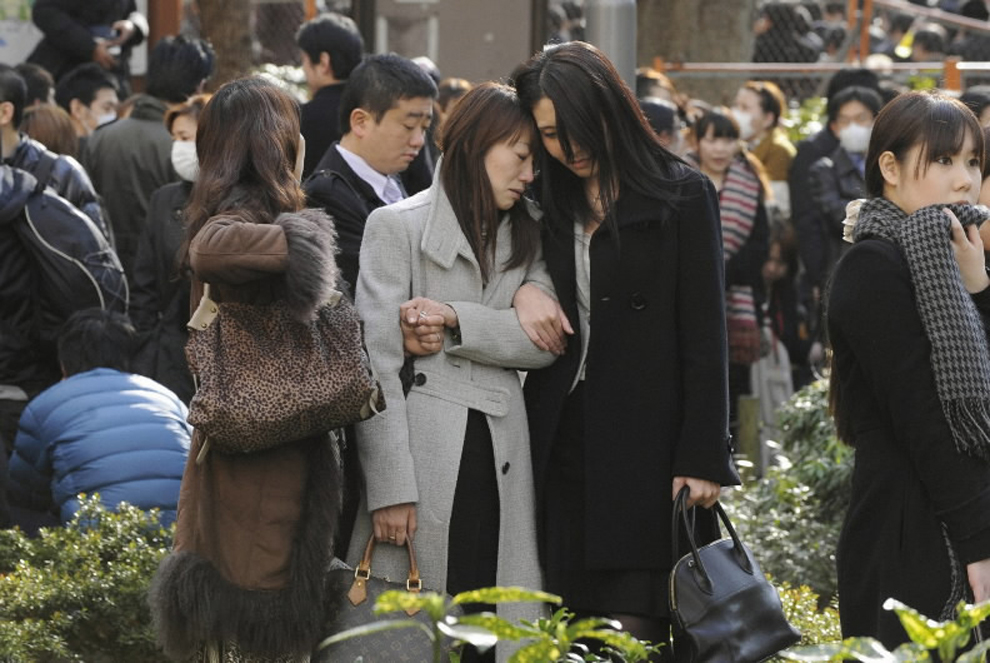
Evacuees stand around Shinjuku Central Park in Tokyo Japan March 11, 2011. A massive 8.9 magnitude quake hit northeast Japan on Friday, causing many injuries, fires and a ten-metre (33-ft) tsunami along parts of the country's coastline. A tsunami warning has been issued for the entire Pacific basin except for the mainland United States and Canada following a huge earthquake that hit Japan on Friday, the Pacific (Reuters)

Tsunami swirls near a port in Oarai, Ibaraki Prefecture (state) after Japan was struck by a strong earthquake off its northeastern coast Friday, March 11. (Kyodo News/Associated Press)

Seismologists pose for the media as they display a seismographic graph showing the magnitude of the earthquake in Japan, on a monitor at the British Geological Survey office in Edinburgh, Scotland March 11, 2011. The biggest earthquake on record to hit Japan struck the northeast coast on Friday, triggering a 10-metre tsunami that swept away everything in its path, including houses, ships, cars and farm buildings.
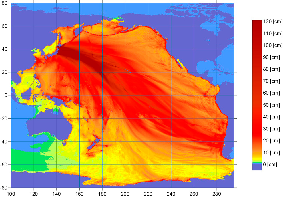
An energy map provided by the National Oceanic and Atmospheric Administration (NOAA) shows the intensity of the tsunami caused by the magnitude 8.9 earthquake which struck Japan on March 11, 2011. A tsunami warning has been issued for the entire Pacific basin except mainland United States and Canada following a huge earthquake that hit Japan on Friday, the U.S. Pacific Tsunami Warning Center said. The warning includes Hawaii and extends from Mexico down to South American countries on the Pacific, the center said. (NOAA/Tsunami Warning Center/)
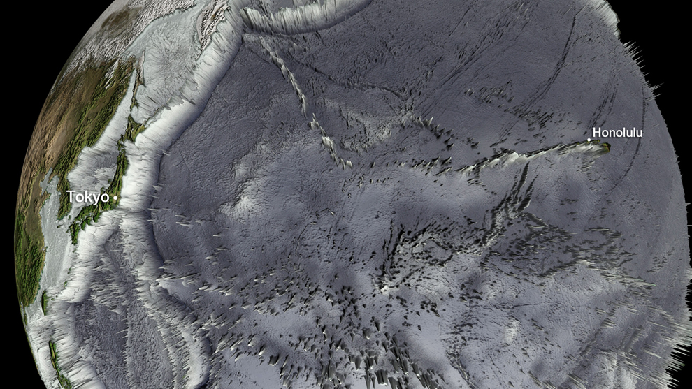
This National Oceanic and Atmospheric Administration (NOAA) Global bathymetry map image released on March 11, 2011 shows features of the ocean floor depth (or bathymetry) from a NOAA ETOPO-1 dataset. The image shows the entire Western Pacific basin. Notice how abruptly the Japanese islands rise out of the ocean. Other coastal Asian areas have much more gradual slopes. The islands and mountain ranges throughout the ocean, visible in this imagery, also affect the tsunami travel time and speed. In the open ocean, tsunamis can travel at speeds up to 500 mph (800 kph). This momentum is what creates such a destructive force as the wave moves inland. Tsunami waves rolled thousands of miles across the Pacific Ocean after a massive earthquake off Japan and washed ashore in Hawaii early March 11, 2011, but the tourist hotspot appeared to escape major damage. As sirens blared and Hawaiian authorities rapidly evacuated low-lying areas, the Pacific Tsunami Warning Center reported wave changes at Waianae Harbor at around 3:24 a.m.
Similar threads
- Replies
- 29
- Views
- 670
- Replies
- 36
- Views
- 2K
- Replies
- 3
- Views
- 369