


Google Earth එකේ එහෙ මෙහෙ යනකොට හිමාලය පාමුල තිබිල කාන්තාරයක් දැක්ක. .විස්තර ටිකක් හෙව්වා..


Taklamakan is one of the largest sandy deserts in the world, ranking 15th in size in a ranking of the world’s largest non-polar deserts. China’s biggest desert experienced its biggest snowfall and lowest temperature after 11 consecutive days of snow. Snow is rare in the desert that covered 337,600 square kilometers, never before had the whole desert been covered.

Details From:http://funnyfunda.com/amazing-places/taklamakan-a-desert-covered-with-snowfall.php
From
en.wikipedia.org
Taklamakan Desert
From Wikipedia, the free encyclopedia
For the novelette by Bruce Sterling see Taklamakan (story).
View of the Taklamakan desert
The Taklamakan Desert (Chinese: 塔克拉玛干沙漠; pinyin: Tǎkèlāmǎgān Shāmò; Uyghur: تەكلىماكان قۇملۇقى, ULY: Täklimakan qumluqi), also known as Taklimakan, and Teklimakan, is a desert in Central Asia, in the Xinjiang Uyghur Autonomous Region of the People's Republic of China. It is the world's 17th largest desert. It is bounded by the Kunlun Mountains to the south, and the desert Pamir Mountains and Tian Shan (ancient Mount Imeon) to the west and north.
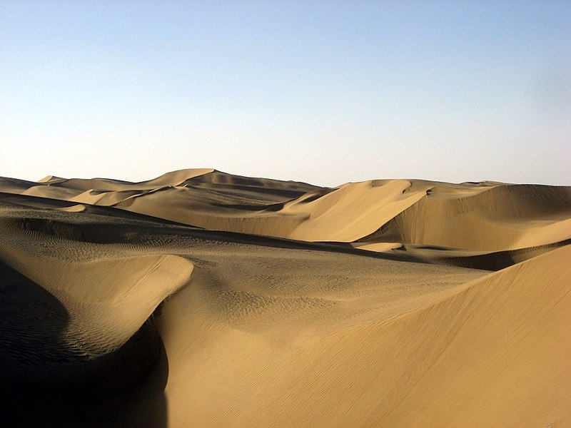
The Taklamakan Desert Ecoregion is a Chinese ecoregion of the Deserts and xeric shrublands Biome.
The name is probably an Uyghur borrowing of Arabic tark, "to leave alone/out/behind, relinquish, abandon" + makan, "place".[1] Popular accounts wrongly claim that Takla Makan means "go in and you will never come out". It may also mean "The point of no return" or "The Desert of Death"[2]

Taklamakan Desert and Tarim Basin

Taklamakan by NASA World Wind

Sand Dunes in Taklamakan Desert, as seen by NASA Landsat-7
Taklamakan is one of the largest sandy deserts in the world,[3] ranking 18th in size in a ranking of the world's largest non-polar deserts.[4] It covers an area of 270,000 km2 (100,000 sq mi) of the Tarim Basin, 1,000 kilometres (620 mi) long and 400 kilometres (250 mi) wide. It is crossed at its northern and at its southern edge by two branches of the Silk Road as travelers sought to avoid the arid wasteland.[5] In recent years, the People's Republic of China has constructed a cross-desert highway that links the cities of Hotan (on the southern edge) and Luntai (on the northern edge). In recent years, the desert has expanded in some areas, its sands enveloping farms and villages as a result of desertification.
Climate

Desert life near Yarkand

A Dust Storm Sweeping the Taklamakan Desert
Taklamakan is a paradigmatic cold desert climate. Given its relative proximity with the cold to frigid air masses in Siberia, extreme lows are recorded in wintertime, sometimes well below −20 °C (−4 °F). During the 2008 Chinese winter storms episode, the Taklamakan was reported to be covered for the first time in its entirety with a thin layer of snow reaching 4 centimetres (1.6 in), with a temperature of −26.1 °C (−15 °F) in some observatories.[6]
Its extreme inland position, virtually in the very heartland of Asia and thousands of kilometres from any open body of water, accounts for the cold character of its nights even during summertime.
Oases
There is very little water in the desert and it is hazardous to cross. Merchant caravans on the Silk Road would stop for relief at the thriving oasis towns.[7]
The key oasis towns, watered by rainfall from the mountains, were Kashgar, Marin, Niya, Yarkand, and Khotan (Hetian) to the south, Kuqa and Turpan in the north, and Loulan and Dunhuang in the east.[5] Now many, such as Marin and Gaochang, are ruined cities in sparsely inhabited areas in the Xinjiang Autonomous Region of the People's Republic of China.[8]
The archeological treasures found in its sand-buried ruins point to Tocharian, early Hellenistic, Indian, and Buddhist influences. Its treasures and dangers have been vividly described by Aurel Stein, Sven Hedin, Albert von Le Coq, and Paul Pelliot.[5] Mummies, some 4000 years old, have been found in the region. They show the wide range of peoples who have passed through. Some of the mummies appear European.[9] Later, the Taklamakan was inhabited by Turkic peoples. Starting with the Tang Dynasty, the Chinese periodically extended their control to the oasis cities of the Taklamakan in order to control the important silk route trade across Central Asia. Periods of Chinese rule were interspersed with rule by Turkic, Mongol and Tibetan peoples. The present population consists largely of Turkic Uyghur people.
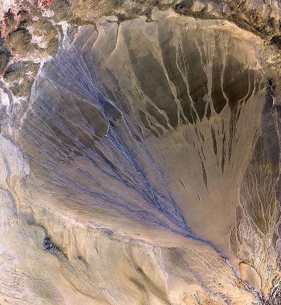
The Molcha (Moleqie) River forms a vast alluvial fan at the southern border of the Taklamakan Desert, as it leaves the Altyn-Tagh mountains and enters the desert in the western part of the Qiemo County. The left side appears blue from water flowing in many streams. The picture is taken in May, when the river is full with the snow/glacier meltwater. [1]
Details From:
http://en.wikipedia.org/wiki/Taklamakan_Desert
විස්තර ගත්තේ report 2 කින්.වැරදීම් තියෙන්න පුළුවන්..උත්සාහය නුබෙ දැනුම ස්වල්පයක් හෝ වැඩි කිරීම බව කරුණාවෙන් සලකන්න.
.විස්තර ටිකක් හෙව්වා..

Taklamakan is one of the largest sandy deserts in the world, ranking 15th in size in a ranking of the world’s largest non-polar deserts. China’s biggest desert experienced its biggest snowfall and lowest temperature after 11 consecutive days of snow. Snow is rare in the desert that covered 337,600 square kilometers, never before had the whole desert been covered.

Details From:http://funnyfunda.com/amazing-places/taklamakan-a-desert-covered-with-snowfall.php
From
en.wikipedia.org
Taklamakan Desert
From Wikipedia, the free encyclopedia
For the novelette by Bruce Sterling see Taklamakan (story).
View of the Taklamakan desert
The Taklamakan Desert (Chinese: 塔克拉玛干沙漠; pinyin: Tǎkèlāmǎgān Shāmò; Uyghur: تەكلىماكان قۇملۇقى, ULY: Täklimakan qumluqi), also known as Taklimakan, and Teklimakan, is a desert in Central Asia, in the Xinjiang Uyghur Autonomous Region of the People's Republic of China. It is the world's 17th largest desert. It is bounded by the Kunlun Mountains to the south, and the desert Pamir Mountains and Tian Shan (ancient Mount Imeon) to the west and north.
The Taklamakan Desert Ecoregion is a Chinese ecoregion of the Deserts and xeric shrublands Biome.
The name is probably an Uyghur borrowing of Arabic tark, "to leave alone/out/behind, relinquish, abandon" + makan, "place".[1] Popular accounts wrongly claim that Takla Makan means "go in and you will never come out". It may also mean "The point of no return" or "The Desert of Death"[2]

Taklamakan Desert and Tarim Basin

Taklamakan by NASA World Wind

Sand Dunes in Taklamakan Desert, as seen by NASA Landsat-7
Taklamakan is one of the largest sandy deserts in the world,[3] ranking 18th in size in a ranking of the world's largest non-polar deserts.[4] It covers an area of 270,000 km2 (100,000 sq mi) of the Tarim Basin, 1,000 kilometres (620 mi) long and 400 kilometres (250 mi) wide. It is crossed at its northern and at its southern edge by two branches of the Silk Road as travelers sought to avoid the arid wasteland.[5] In recent years, the People's Republic of China has constructed a cross-desert highway that links the cities of Hotan (on the southern edge) and Luntai (on the northern edge). In recent years, the desert has expanded in some areas, its sands enveloping farms and villages as a result of desertification.
Climate

Desert life near Yarkand

A Dust Storm Sweeping the Taklamakan Desert
Taklamakan is a paradigmatic cold desert climate. Given its relative proximity with the cold to frigid air masses in Siberia, extreme lows are recorded in wintertime, sometimes well below −20 °C (−4 °F). During the 2008 Chinese winter storms episode, the Taklamakan was reported to be covered for the first time in its entirety with a thin layer of snow reaching 4 centimetres (1.6 in), with a temperature of −26.1 °C (−15 °F) in some observatories.[6]
Its extreme inland position, virtually in the very heartland of Asia and thousands of kilometres from any open body of water, accounts for the cold character of its nights even during summertime.
Oases
There is very little water in the desert and it is hazardous to cross. Merchant caravans on the Silk Road would stop for relief at the thriving oasis towns.[7]
The key oasis towns, watered by rainfall from the mountains, were Kashgar, Marin, Niya, Yarkand, and Khotan (Hetian) to the south, Kuqa and Turpan in the north, and Loulan and Dunhuang in the east.[5] Now many, such as Marin and Gaochang, are ruined cities in sparsely inhabited areas in the Xinjiang Autonomous Region of the People's Republic of China.[8]
The archeological treasures found in its sand-buried ruins point to Tocharian, early Hellenistic, Indian, and Buddhist influences. Its treasures and dangers have been vividly described by Aurel Stein, Sven Hedin, Albert von Le Coq, and Paul Pelliot.[5] Mummies, some 4000 years old, have been found in the region. They show the wide range of peoples who have passed through. Some of the mummies appear European.[9] Later, the Taklamakan was inhabited by Turkic peoples. Starting with the Tang Dynasty, the Chinese periodically extended their control to the oasis cities of the Taklamakan in order to control the important silk route trade across Central Asia. Periods of Chinese rule were interspersed with rule by Turkic, Mongol and Tibetan peoples. The present population consists largely of Turkic Uyghur people.
The Molcha (Moleqie) River forms a vast alluvial fan at the southern border of the Taklamakan Desert, as it leaves the Altyn-Tagh mountains and enters the desert in the western part of the Qiemo County. The left side appears blue from water flowing in many streams. The picture is taken in May, when the river is full with the snow/glacier meltwater. [1]
Details From:
http://en.wikipedia.org/wiki/Taklamakan_Desert
විස්තර ගත්තේ report 2 කින්.වැරදීම් තියෙන්න පුළුවන්..උත්සාහය නුබෙ දැනුම ස්වල්පයක් හෝ වැඩි කිරීම බව කරුණාවෙන් සලකන්න.


