What happened to Malaysia Airlines Flight 370?
What happened to Malaysia Airlines Flight 370?
Source
http://edition.cnn.com/interactive/2014/03/world/malaysia-flight-map/index.html?iid=article_sidebar
About an hour after taking off from Kuala Lumpur, Malaysia on Saturday, March 8, a Boeing 777-200ER jetliner went missing while flying to Beijing. Below is a brief summary of what we know about the path of flight 370.
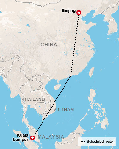
The scheduled route
The Boeing 777-200ER takes off from Kuala Lumpur, the Malaysian capital, at 12:41 a.m. Saturday (12:41 p.m. Friday ET).
The red-eye flight is scheduled to arrive in Beijing at 6:30 a.m. the same day, after a roughly 2,700-mile (4,350-kilometer) journey.
There are 239 people on board: 227 passengers and 12 crew members. Five of the passengers are younger than 5 years old.
Lost contact, apparent course change
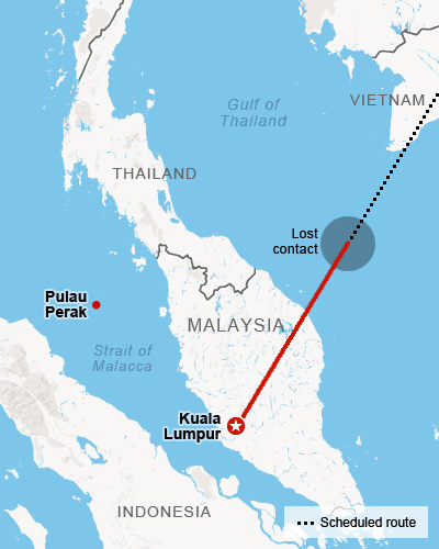
Around 1:30 a.m., air traffic controllers in Subang, outside Kuala Lumpur, lose contact with the plane over the sea between Malaysia and Vietnam. The plane's transponder, which identifies the aircraft and relays details like altitude and speed to controllers, stops transmitting.
A senior Malaysian air force official on Tuesday says the flight was hundreds of miles off course and traveling in the opposite direction from its original destination. It was last tracked over over Pulau Perak, a tiny island in the Strait of Malacca at about 2:40 a.m., over an hour after air traffic controllers in Subang lost contact with the aircraft.
At a news briefing Wednesday, however, Gen. Rodzali Daud, head of the Malaysian Air Force, and other officials say it isn't yet clear whether the object that showed up on military radar flying over the sea northwest of the Malaysian coast early Saturday was the missing plane.
Adding to the puzzle, the Wall Street Journal reported Thursday that the plane may have continued flying for four hours after its last reported contact, attributing the information to two unidentified sources who were citing data automatically transmitted to the ground from the aircraft's Rolls-Royce-manufactured engines. A senior aviation source with detailed knowledge of the matter told CNN's Richard Quest on Thursday the WSJ account in incorrect. The paper later corrects its story, saying it was satellite data, not engine data, that drove the belief the plane continued to fly.
The search
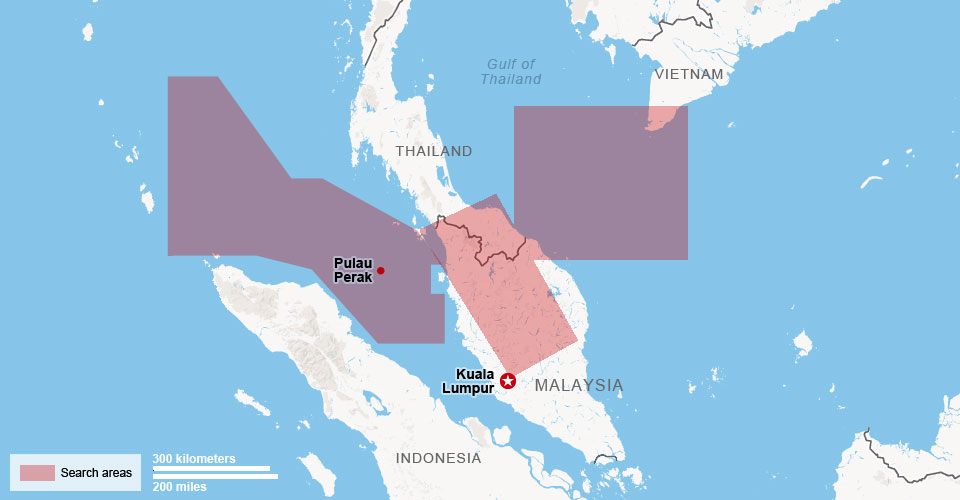
Several planes, ships and search crews from 14 countries begin scouring the South China Sea near where the plane was last detected. After debris in the area and an oil slick turn out to be unrelated to the plane, the search area is expanded to include the waters west of Malaysia. China's State Administration for Science, Technology and Industry for National Defense release satellite photos of possible wreckage, but later announce that the release was a mistake, and the debris in the photos was unrelated to Flight 370.
The extended search area
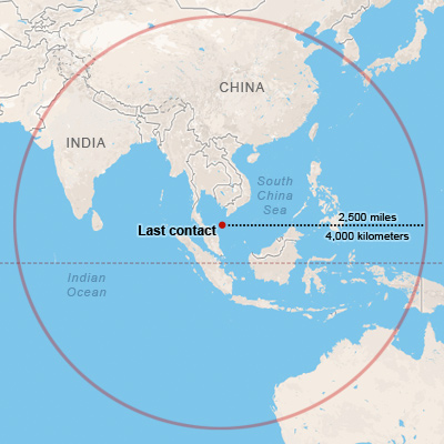
Flight 370 was fueled for a trip to Beijing. Based on fuel estimates, the aircraft could have flown an additional 2,500 miles after the point of last contact.
Malaysian authorities said Thursday they believe several "pings" of data from the airliner's service data system, known as ACARS, transmitted to satellites in the four to five hours after the last transponder signal, a senior U.S. official told CNN.
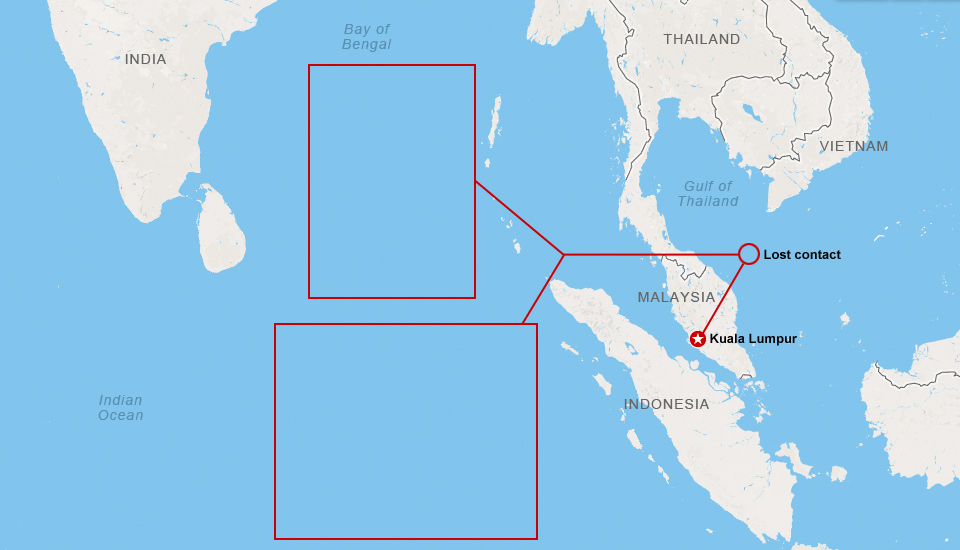
This new information, combined with known radar data and knowledge of fuel range leads officials to believe the plane may have made it to the Indian Ocean.
New details purport two theories
On Friday, CNN learns of a classified analysis of electronic and satellite data, conducted by the United States and Malaysian governments, that calculates Flight 370 likely crashed into the Indian Ocean on one of two possible flight paths. Both flight paths assume the aircraft headed west after losing contact with air traffic controllers, and crossed the Malay peninsula. One flight path suggests the plane crashed into the Bay of Bengal off the coast of India, and the other has it crashing in the Indian Ocean, according to the analysis.
Satellite 'handshakes' narrow search
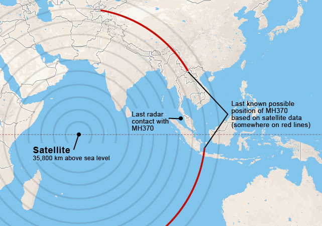
As the focus of the investigation shifts, so too does the focus of the search. "The plane's last communication with the satellite was in one of two possible corridors: a northern corridor stretching approximately from the border of Kazakhstan and Turkmenistan to northern Thailand, or a southern corridor stretching approximately from Indonesia to the southern Indian Ocean," Malaysia's Prime Minister Najib Razak said Saturday.
The map to the left, based on a handout from the Prime Minister's office, highlights the focused search area - much of which falls over land.
While official contact was lost with Flight 370 about 45 minutes after takeoff, officials believe a combination of military radar data and a satellite-based system called ACARS provide hints regarding the path of the plane. Though no actual data was transmitted via satellite, it still appears to have made contact through hourly 'handshakes,' the last instance being at 8:11 a.m. local time somewhere along the red lines.
Sources: Malaysia Civil Aviation Authority, Malaysia Prime Minister's office, CNN, flightradar24.com, Google Maps