
At first glance you might mistake a bell-mouth spillway for a watery vortex into another dimension. What can only be described as a giant hole in the water is actually a method for controlling the release of flows from a dam or levee into a downstream area. These spillways help prevent floods from ‘dam’-aging or destroying a dam.


SPILLWAYS - A spillway is a structure used to provide for the controlled release of flows from a dam or levee into a downstream area, typically being the river that was dammed
- Spillways release floods so that the water does not overtop and damage or even destroy the dam. Except during flood periods, water does not normally flow over a spillway
- In contrast, an intake is a structure used to release water on a regular basis for water supply, hydroelectricity generation, etc.
- Floodgates and fuse plugs may be designed into spillways to regulate water flow and dam height
- Other uses of the term “spillway” include bypasses of dams or outlets of a channels used during highwater, and outlet channels carved through natural dams such as moraines
Source: http://en.wikipedia.org/wiki/Spillway
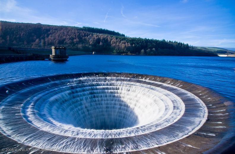
BELL-MOUTH SPILLWAYS
- Some spillways are designed like an inverted bell so that water can enter all around the perimeter. These uncontrolled spillway devices are also called: morning glory, plughole, glory hole, or bell-mouth spillways
- In areas where the surface of the reservoir may freeze, bell-mouth spillways are normally fitted with ice-breaking arrangements to prevent the spillway from becoming ice-bound
Source: Wikipedia


LADYBOWER RESEVOIR
- The images above are from the spillways located at the Ladybower Resevoir
- The Ladybower Reservoir is a large Y-shaped reservoir, the lowest of three in the Upper Derwent Valley in Derbyshire, England
- The River Ashop flows into the reservoir from the west; the River Derwent flows south, initially through Howden Reservoir, then Derwent Reservoir, and finally through Ladybower Reservoir
- Its longest dimension is just over 3 miles (5km), and at the time of construction it was the largest reservoir in Britain (1943)
Source: Wikipedia


MONTICELLO DAM - The Monticello Dam is a dam in Napa County, California, United States constructed between 1953 and 1957
- It is a medium concrete-arch dam with a structural height of 304 ft (93 m) and a crest length of 1,023 ft (312 m)
- It contains 326,000 cubic yards (249,000 m³) of concrete. The dam impounded Putah Creek to cover the former town of Monticello and flood Berryessa Valley to create Lake Berryessa, the second-largest lake in California
- The capacity of the reservoir is 1,602,000 acre•ft (1,976,000 dam³). Water from the reservoir is supplied mostly to the North Bay area of San Francisco
- The dam is noted for its classic, uncontrolled spillway with a rate of 48,400 cubic feet per second (1370 m³/s) and a diameter at the lip of 72 ft (22 m).
Source: Wikipedia


SOURCES
- Wikipedia: Spillways
- Wikipedia: Ladybower Resevoir
- Wikipedia: Monticello Dam


+REP

 Thankz!!


